Geography of Mewar
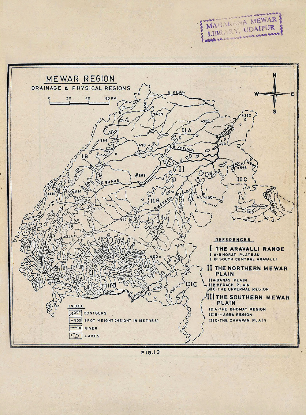
Mewar, the ancient name of this geographical area of Rajputana, now Rajasthan was Medpat, as the Mer Adivasi tribes were the original settlers here. It lies on Latitude 25. - 28 to 23. - 49 and Longitude 75. - 49 to 73. - 1. The land length from North to South is 237.53 kilometres and the width from East to West is 219.51 kilometres. It is spread over an area of 32869.53 square kilometres.
Topography of Mewar
The famed and one of the oldest mountain ranges in the world, Aravalli's run North to South, starting from Delhi's famous Ridge through Haryana, Jaipur and Ajmer in the north and ending just short of Himmat Nagar in Gujarat in the south. The hills are some kilometres wide jutting into Kota and Bundi area; at some places covering a large area of the land and at some places it is just a thin strips of hilly area with ravines and heavy forest. But, besides this there are small hillocks, plateaus like that of Chittorgarh strewn in the eastern part of the land. However, the northern and eastern portions of Mewar are mostly made up of an elevated plateau while the western and southern portions are full of rocky hill areas with dense forests. The highest point in the Aravalli's in Mewar is at Kumbhalgarh, which is at an height of 1100 meters from the Sea level.
Mewar is a region in the south-central part of Rajasthan state of India. The boundaries of Mewar are surrounded by Ajmer in the North, Tonk in the North East, Hadoti Bundi, Kota and Pratapgarh Devaliya in the East, Malwa now part of Madhya Pradesh in the South East, Gujarat, Banswara and Dungarpur in the South, Idar in the South West and Marwar and Sirohi in the West. In the Sultanate Era and later during Mughal rule there were attacks from the neighbouring states of Gujarat from the south or from Malwa and from the North from Delhi and Agra via Ajmer, Deoli and Jahajpur. The Aravalli hills greatly helped Mewar to defend it self against the enemies or indulge in Guerrilla warfare as adopted by Maharana Pratap against Akbar and later by Maharana Raj Singh against Akbar's successors.
Now, it includes the present-day districts of Bhilwara, Chittorgarh, Pratapgarh, Rajsamand, Udaipur, Pirawa Tehsil of Jhalawar District of Rajasthan, Neemuch and Mandsaur of Madhya Pradesh and some parts of Gujarat. The Mewar region lies between the Aravalli Range to the northwest, Ajmer-Merwara and Shahpura to the north, Jodhpur and Sirohi in the west, Idar in the South-west, Vagad region comprising of Dungarpur, Banswara and Pratapgarh to the south, Nimach, Tonk, Nimbaheda, Bundi and Kota to the east and the Dewali region near Jaipur to the North-east.
Flora and Fauna of Mewar
In the olden days Mewar was full of wild life with Tigers in large numbers, followed by Panthers, Shambhar, Antelopes of all verities, Blue bucks (Neel Gaya, cow), Black Sloth Bear, Wild boars, Hyenas, Jackals, Wild Cats, Hairs and many more smaller animals. The tigers have totally disappeared from Mewar but other wild animals are still found, though now in much smaller numbers.
The Bird life in Mewar was found in abundance both local species and migratory birds which fly hundreds of kilometres from distant Siberia, China and Mongolia regions in the winter. Non migratory birds like Pigeons, House Sparrows, Crows, Eagles, Falcons, Kites, Vulture's, Woodpeckers, Hoopoes, Indian Robin, Koel, Night Jars, Honey Sucker's, Bee Eaters, Doves, Warblers, Pied Crested Cuckoo, Peacocks, Partridges, Sandgrouse, Quail, Junglefowls, Owls, Indian Grey Hornbills, Crow Pheasant, Indian Myna, Wagtail, Black Drongo, Parrots and many others are still found in the cities and neighbouring areas. The migratory birds like many variety of Ducks, Bar headed Geese, Flamingo's, Sarus Cranes, variety of Stocks and non migratory water birds are like Indian Reef Heron, Night Heron, Spoon Bill, Darter or Snake Birds, Cattle Egrets, Lapwing, Avocet, Stilt, Snipe etc.
As regards the Flora of Mewar it was mostly Tropical Dry Deciduous Forest with very thick in the Western hills and in the South and thin in the East, which was the granary of Mewar. The forests in Mewar are full of variety of trees, prominent among them are Peepal, Banyan, Custard Apple, it grows naturally in abundance in the valleys and is a great source of income for the Bheel Adivasi tribes inhabiting in theses parts of Mewar. Frangipani, Amaltas, Harshingar, Lagerstroemia, small variety of Mangoes, peculiar to Mewar, Bamboo forest, Weeping Fig, Peach tree, Ashoka, Indian Tulip tree, Khirni, Mahua, Amla, Roheda, Kachnar or Bauhinia, Bael, Semal, Imli, Cassia, Neem, Kaith, Kamrakh, Gulmohur, Vilaiti Keekar, Jacaranda, Wild Date Palm, Ber and among the shrubs most common is variety of thorny Cactus. As far hedges are concerned Bougainvillea seem to be the most popular one, with many colours and even variegated variety, but there are others like Tecoma (Trumpet bushes) ever green with yellow belled shaped flowers and Hibiscus.
Rivers of Mewar
The rivers of Mewar flow according to the great Indian watershed divide which is about twenty five kilometres west of Udaipur. From here the rivers flowing to the west drain out into Sabarmati in Gujarat, which flows into the Gulf of Khambhat. The rivers flowing to the east drain into Bedach and Banas which feed the great Bisalpur Dam near Tonk. Incidentally Bisalpur supplies water to Tonk, Jaipur and Kishangarh. The overflow of Bisalpur drains in to River Chambal, then Jamuna and eventually Ganga which carries the water to Bay of Bengal.
- Chambal - It is one of the oldest rivers of India. It only flows 9 miles in Mewar near Bhaisrodgarh.
- Banas - The Banas is a river which lies entirely within the state of Rajasthan in western India. It is a tributary of the Chambal River, itself a tributary of the Yamuna, which in turn merges into the Ganga. The Banas is approximately 512 kilometres in length. The river originates in the Veron ka Math situated in Khamnor Hills of the Aravalli Range, about 5 km from Kumbhalgarh in Rajsamand district. It flows northeast through the Mewar region flowing through Nathdwara and enters Mandalgarh. It flows 180 miles of length in Mewar. Kotari and Khari rivers emerging from Aravalli ranges and later merges into Banas river.
- Berach River- a tributary of the Banas River, is a river of Rajasthan state in western India. The river belongs to the Ganga River basin. The Berach originates in the hills of Udaipur district, south-west of Udaipur, and has a length of 157 km and basin area of 7,502 km². It flows northeast through Udaipur, Chittorgarh and Bhilwara districts, joining the Banas near Bigod village of Bhilwara district. Sisarama River, Ahar River, Gambhiri River, and Orai River merge in Berach river.
- Wakal river- It emerges from the western ranges of Gogunda and flows 50 miles through Ogana, Manpura, Kotada. It later passes through Idar and merges into the river Sabarmati in Gujarat.
- Som river- It merges from near the ranges of Bichameda and merges into Mahi river near Dungarpur. Its tributary Jhakam river flows from Sadri ranges via Pratapgarh and Dhariyavad merges into the river Som.
Lakes of Mewar
Lake Udai Sagar: Maharana Udai Singhji, r. 1537 – 1572, established Udaipur as the new capital of Mewar. Along with that he also got a dam constructed on River Ayed that resulted in a lake that was named after him. The completion of this lake took approximately 5 years, between (1569-1564 CE). Flowing 6 miles east of Udaipur this lake is 2.5 miles long and 2 miles broad. The first time it reached its full capacity was in the year 1564. Prime reason for the construction of this dam was the security of the newly instated capital, Udaipur as well as to ensure substantial water supply for irrigation and personal consumption.
Lake Raj Samudra: Raj Samudra also known as Lake Rajsamand is an exquisite example of a water body. While still a bachelor, Maharana Raj Singhji, r. 1653 – 1680, went to Jaisalmere for his wedding and saw the possibility of lake at this place. In 1661, he made a halt to worship Shri Roopnarayanji, when he conceptualized the idea of constructing a huge water reservoir near village Kankroli as a relief project for the common man. Its enormity can be imagined by the fact that it embraces the boarders of almost 12 villages in its circumference. In 1662 CE the excavation for the foundation of this enormous lake started simultaneously in square formation at different places. Various departments were appointed to monitor this mammoth task. On April 17 1665 CE, Ranchod Rai son of the royal priest Garibdas laid its foundation stone along with five gems.
On June 30 1671 CE proved to be the year of drought. ‘Pakhals’ (leather water pouches) were used to collect water from various nearby places to fill the lake. Thereafter an auspicious time for boating was announced. By 1673 CE reasonably good rainfall was registered that managed to raise the water level of the lake to about 8 feet. Skilled artisans from Lahore, Gujrat and Surat prepared water boats that were cast in the lake on July 27, 1674 and the inaugural celebration of the lake commenced in 1675. The Maharana observed fast on ‘Ashtami’ (eighth day of the lunar calendar) and on ‘Navmi’ (ninth day of the lunar calendar) he reached the ‘mandap’ (covered structure with pillars temporarily erected to perform prayer ceremony) near the lake to worship Lord Varun (Rain God) along with his family, feudal lords, statesmen, other nobles and priests. 9 ‘kunds’ (a center place in the mandap where fire is lit and oblations are made) were made in two separate mandaps and the ‘yagna’ (Vedic sacrifice or ritual worship) – ‘havan’ (sacred fire) were performed. Next day, the Maharana accompanied by his family set out bare feet to take ‘parikrama’ (ritual of moving clockwise around an object of devotion as an indication of reverence) of the lake; led by the royal priests and Brahmins chanting the Vedas. Distance of 14 kos, (equal to about 44.8 kms), was covered in 5 days that culminated on ‘Purnima’ (full moon day). The lake was formally inaugurated by offering ‘purnahuti’ (ceremony symbolizing of complete offering away of oneself). Thereafter, the Maharana performed gold ‘tula-daan’ (a ritual where a sacred donation is made by weighing it against the weight of the person performing it) in which he also weighed his grandson, Amar Singh with himself. Total of 12000 tolas (approximately12 kgs.) of gold was donated that day. As per Rajsamudra inscription ‘Saptsagar’ was also donated on the same day. Queens, accompanied by priests joined in to offer silver tula-daan. The Maharana then presented 12 villages to the royal priest Garibdas; to the other Brahmins he presented - villages, gold, silver etc. Priests Charan and Bhatt (bards) were given Elephants, Horses, clothes etc. This significant occasion was commemorated by the presence of kings and nobles of various states. Valuable gifts of Elephants, Horses etc. were exchanged between them and the Maharana, as a mark of friendship. About 46000 Brahmins and locals were fed and clad that day. Total expenditure was approximately Rs. 1,05,07,608. On the Nauchoki dam of this magnificent lake embankment, 25 artistically carved and engraved colossal rocks bear inscription of 25 ‘sarg’ (cascade) of the great genre – ‘Rajprashasti, describing the glorious past of Mewar. These stone inscriptions are believed to be the longest engravings in the history of the country. This extraordinary masterpiece was created by Ranchod Bhatt, a Teleng by cast from Kathodi lineage. Credit for getting it engraved on the rocks goes to Maharana Jai Singhji, r. 1680 – 1698.
Lake Jai Samudra: 32 miles to the southeast of Udaipur is located the world famous man made, sweet water lake, Jai Samudra. It was constructed between 1686-1691 CE and owes its existence to Maharana Jai Singhji. When full, it covers an area of more than 7 miles in length and 6 miles in width. There are 3 islands on the lake, two are known as Baba ka Magra while the third one is known as Pairi. A marble dam approximately 1000 feet long, 95 feet high and 50 feet broad at the base, exists between two hillocks. A similar dam measuring 1300 feet exists behind this dam. Six exotic cenotaphs flank the lake bank. Beneath the cenotaphs, are six graceful Elephants carved from a single stone. On May 22 1691 CE, Maharana Jai Singhji laid the foundation of the lake and the occasion was celebrated by donating gold after a tula-daan. The dam also houses Narmdeshwar Shiva temple, the construction of which was started by Maharana Jai Singhji but he could not complete it during his lifetime. Seeing the deluge of CE.1875 Maharana Sajjan Singhji, r. 1874 – 1884, spent Rupees 2 lakh to fill just about 2/3rd of the vast area between the two dams with stone, mud and lime. The hill to the south of the dam was dotted with Palaces of Maharana Jai Singhji which were later restored by Maharana Sajjan Singhji. With dense forest area all around it, Jaisamand is an enormous, charismatic lake.
Thur Talab (Pond): Maharana Jai Singhji got Thur Talab constructed near village Thur, approximately 5 miles northwest of Udaipur. The foundation of this talab was laid in 1687 CE Lake Pichola: Approximately 625 years ago, between 1383-85, Maharana Lakha, r. 1382 – 1421, (Lakshya Singh) got a lake constructed by getting a temporary dam built between Machala Magra and Rana Magri, (on the hill on which present day City Palace is built). Lake Pichola got its name from a nearby village, Picholi. Later Maharana Udai Singhji was instrumental in providing it a grand look by replacing the ordinary, temporary structure with a more concrete one. The bank of the lake is dotted with beautiful temples, bridges, old ‘havelis’ (mansions) and the magnificent City Palace. When this dam collapsed in 1795 Maharana Bhim Singhji, r. 1778 – 1828, got it repaired in a much sturdier manner for it to withhold floods in the future. Glorious structures such as Jagmandir and Jagniwas stand tall within this lake. The lake was further strengthened and beautified by Maharana Jawan Singhji, r. 1828 – 1838, and Maharana Swarup Singhji, r. 1842 – 1861, during their respective reigns making it world famous for its beauty and strength. To the east of Lake Pichola is Doodh Talai, a small pond which was constructed to meet the water requirement of animals of a Banjara, a trader. Today it presents itself as a renowned tourist spot.
In 1668 Maharana Raj Singhji I established Lake Rang Sagar in memory of his son Rajkumar Sultan Singhji ‘Surtran’. Foundation of Rang Sagar was laid by Kunwar Jai Singhji, currently it is part of Lake Pichola. Udaipur city was founded by Maharana Udai Singhji II during his reign when Kumariya Talab was also created for the Kumhar community, (makers of bricks and earthen pots). During Maharana Sajjan Singhji’s regime in 1874 it was connected with Lake Rang Sagar. Similarly Maharana Sajjan Singhji in the year 1874 got two ponds – Pond Kumariya and Pond Amar Kund – which were constructed during the reign of Maharana Ari Singh, r. 1761 – 1773, merged into Lake Rang Sagar thus expanding and giving it a grand form.
Jana Sagar: In 1668 CE Maharana Raj Singhji I got this water body created in Village Badi situated 10 Kms away to the west of Udaipur in memory of his mother Rajmata Janade (Karmitiji). The primary reason for the creation of this water body was to meet the irrigation requirement of Village Badi and other close by villages as well as to ensure that Lake Fateh Sagar and Lake Dewali would have adequate water all year round. This dam was strong enough to withstand the floods of 1795. A sliver tula-daan was performed during the creation of this lake and priest Garibdas was gifted village Gunhand (Gilund) and Depura. Rs. 6,88,000 was the total expenditure on the construction of this water body.
The farsightedness of Maharana Raj Singh I: Maharana Raj Singh I pioneered the technique of changing the course of water flow to give it a permanent form. The course of water flow of River Obey Var flowing from Ubeshwar, the famous pilgrim site of Mewar was turned to join River Morwani between the years 1652-80. Thus this water started entering Lake Jana Sagar and Lake Fateh Sagar. Prior to this water from River Ubeshwar would enter Lake Chota Madar. The 350 year old dam created on this river is still functional.
Lake Swarup Sagar: Constructed during the reign of Maharana Swarup Singhji, this lake is situated in place of Kalalya Shivsagar Pond, which was named after the Shiv temple of Kalal community. In the year 1845 Maharana Swaroop Singhji gave this pond the form of a lake and so it came to be known as Swarup Sagar. Swarup Sagar is interconnected with Lake Pichola, Lake Rang Sagar and Lake Kumariya.
Lake Fateh Sagar: Approximately 1.5 miles north of Udaipur was a small pond called Dewali ka Talab, built by Maharana Jai Singhji. It derived its name from village Dewali where it was initially constructed by Maharana Jai Singhji in the year 1680. The dam on this pond was not very high. During the reign of Maharana Bhim Singhji the earthen dam got washed away in floods; later in 1889 Maharana Fateh Singhji, r. 1884 – 1930, got it restored and renovated to form a lake. Its Foundation was laid by Prince Arthur, Duke of Connaught and Strathearn, Commander of The Bombay British Army, and the third son of Queen Victoria, hence it was originally named Connaught dam. Later the Duke suggested that the enlarged and restored water reservoir be called Fateh Sagar hence the lake was renamed Fateh Sagar. Prior to the construction of Jana Sagar (Badi Lake) water from river Morwani would flow into Fateh Sagar; because of Jana Sagar the lake was and continues to be fed by river Hathi Dhara and Chikalwas canal that overflows to Jana Sagar enters Fateh Sagar. Apart from this, the overflow of Lake Pichola is diverted into Rang Sagar and Swarup Sagar and the overflow of these two lakes is further directed through a controlled inlet canal that leads to Lake Fateh Sagar. The same Dewali Talab is now popularly known as Lake Fateh Sagar.
Chikalwas Feeder Canal: A dam was constructed to the west of Udaipur near village Chikalwas, on river Ayed along with a feeding canal to link it with Lake Fateh Sagar to ensure adequate water supply to the lake. During monsoons the overflow of Ayed River is diverted through this canal into Lake Fateh Sagar. This canal was constructed during in 1890 during the reign of Maharana Fateh Singhji. On August 13, approximately 129 years back, history was created by Maharana Fateh Singhji by diverting water into Chikalwas feeder canal and this plan is now referred to as - ‘The world’s first river linking project’. The Engineer in the service of Mewar then was Mr Campbell Thompson. Thus, Mewar was then the only state in the world to display examples of inter-linkage of lakes and inter connection and diversion of rivers. Lake Govardhan Sagar: In 1857 Maharana Swarup Singhji got a lake and a cowshed constructed approximately 3 kms. west of Lake Pichola. The same reign saw the replacement of rock walls by a gate that led Lake Govardhan to join Lake Pichola.
Indra Sarovar: Maharana Mokal, r. 1421 – 1433, got Indra Sarovar at Eklingnathji renovated and restored. In order to beautify it Maharana Raj Singhji I got the dilapidated Indraser (Indra Sarovar) dam replaced with a new dam. The water from this lake has forever been used for the worship of the supreme Deity of Mewar, Shree Eklingnathji.
Baghela Talab: Situated in the southwest corner of Shree Eklingnathji temple, the Baghela Talab was constructed by Maharana Mokal in memory of his brother Badh Singh. The incredible strategic micro-management of creation, expansion, preservation, direction of water bodies by the Maharanas of Mewar has taken the world by surprise. Confined to merely 470 kms the small Girwa valley boasts of systematic inter-connection and inter-linking of various rivers and water bodies by the then Maharanas. This is considered to be the best example of using available local water resources to systematically conserve and manage rain water. Since the past 600 years Maharanas of Mewar have continuously demonstrated before the world the importance of water conservation by implementing their traditional techniques of water conservation by using their self-created water bodies which are still the matchless water reservoirs of effective and successful ways of water harvesting and harnessing.
The concept of changing the course of a flowing river by Maharana Raj Singhji I and merging canals with rivers by Maharana Fateh Singhji can be used as examples for water bodies across India to tackle the future water crisis of the country.
Apart from the above mentioned world famous lakes, Maharanas of Mewar have been pioneers in the creation of various water projects such as - dams, wells, step-wells, ponds and lakes. Small and big water reservoirs such as - Heera Talai, Dewali Talab, Khemli Talab, Chota Madar, Bada Madar, Nela Talab, Rundela Talab and Roop Sagar have been important sources of drinking water and irrigation, spread across the region of Mewar. Currently in the race for development many of these water bodied have either already lost their existence or are on the verge of extinction.
Wild Life Sanctuary in Mewar
The Aravalli Range, which forms the north-western boundary of the region, is composed mostly of sedimentary rocks, like marble and Gray Stone, which has traditionally been an important construction material in Mewar. The region is part of the Khathiar-Gir dry deciduous forests' ecoregion. Protected areas include the Jaisamand Wildlife Sanctuary, the Kumbhalgarh Wildlife Sanctuary, the Sajjangarh wildlife Sanctuary, the Bassi Wildlife Sanctuary, the Gandhi Sagar Sanctuary and the Sita Mata Wildlife Sanctuary.
The Climate of Mewar
Mewar has a semi tropical dry climate. Rainfall averages 660 mm/year, and is generally higher in the southwest and lower in the north-eastern region. Over 90% of the rain typically falls in the period of June to September every year during the southwest monsoon. The weather in Mewar is cold from November to end February, winter months are the best time to visit, but even the Monsoon months from July to October are very pleasant and many visitors prefer it as Monsoon destination. The summer months from April to June are hot and dry.
Mountain Passes in Mewar
- Jilwada Pass (Paglaya nal)- Route to reach Mewar from Marwar
- Someshwar Pass – Its few miles north of Desuri Pass
- Hathiguda Pass- Its 5 miles south of Desuri pass. The fort of Kumbhalgarh is situated above this pass.
- Bhanpura Pass- Its six miles south of Ghanerao, also famous for the Ranakpur Jain temples.
Subscribe to Newsletter
Eternal Mewar Udaipur India
© 2018 Eternal Mewar, All Rights reserved
Powered by Nexithon
Copyright © 2025, Shriji Dr. Lakshyaraj Singh Mewar of Udaipur - Concept Developer, Eternal Mewar, All Rights Reserved